

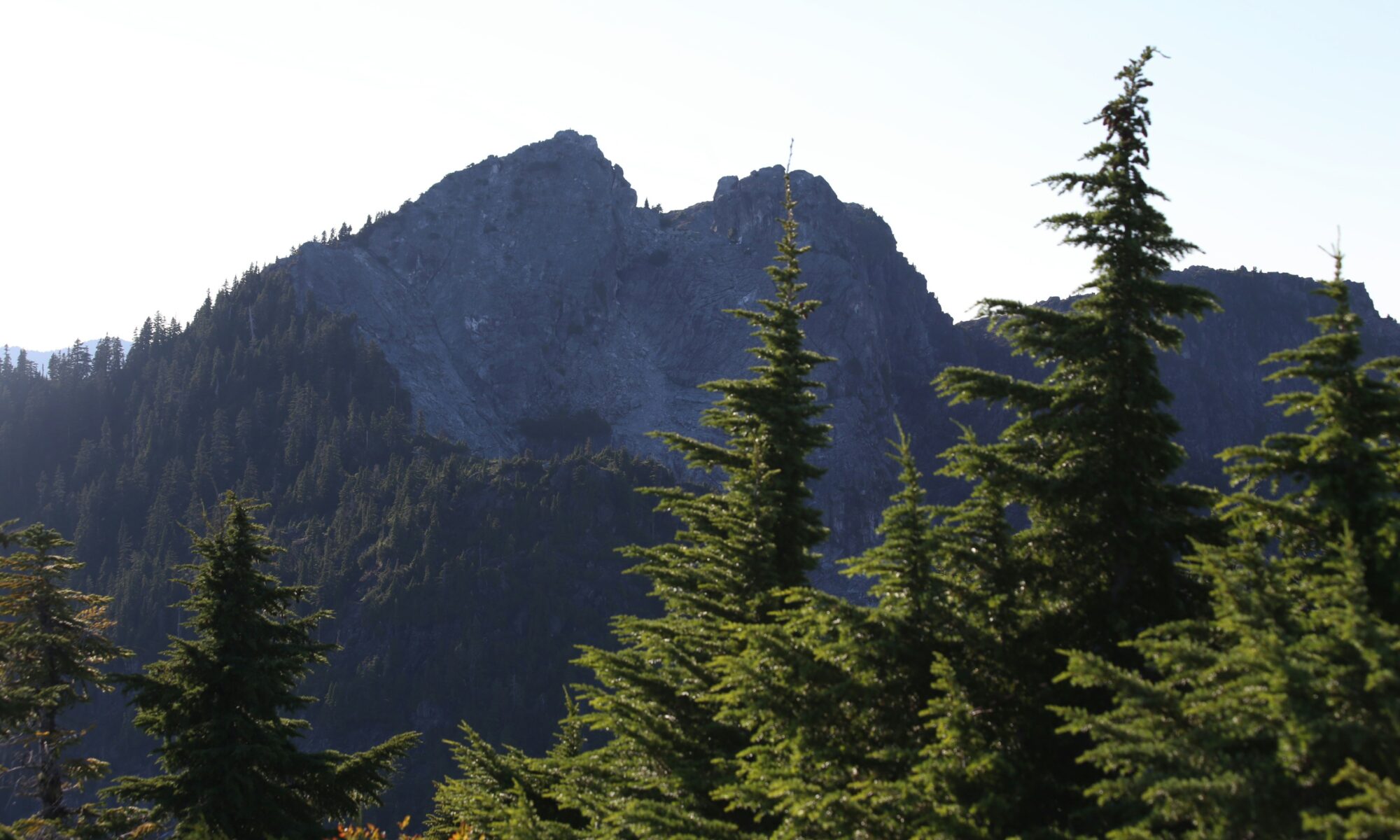
A 16-year-old hiker was rescued from a dangerous cliff in British Columbia after using artificial intelligence during his mountain preparations. But was it human error, misleading AI guidance, or a combination of both?
A 16-year-old Canadian teenager was rescued by helicopter on 3 October 2026 after becoming stranded on a steep rock face on Crown Mountain, near Vancouver, British Columbia.
The teenager, Bryce Vincent Gowryluk, had consulted Claude, the artificial intelligence chatbot developed by Anthropic, while preparing his mountain excursion.
Initial reports suggested that AI-generated directions had contributed to his navigational mistake. However, the teenager subsequently challenged that interpretation, saying he had accidentally entered a technical climbing route and that Claude had not instructed him to take it.
The incident has sparked a wider debate about the reliability of artificial intelligence for mountain navigation — and the responsibility of those using it.
1. A Mountain Hike That Turned Into a Rescue Operation
On Saturday 3 October, Gowryluk set out from Vancouver for a challenging excursion between Grouse Mountain and nearby Crown Mountain.
He took the gondola up Grouse Mountain before continuing towards Crown Mountain, following a route that involved rocky terrain, steep slopes and significant elevation changes.
The excursion was expected to take approximately eight hours.
Although Gowryluk regularly practised indoor rock climbing and had hiking experience, the terrain presented navigational difficulties.
He intended to reach the Crown Couloir, a steep route on the mountain, but mistakenly entered the Widowmaker Arete.
The Widowmaker is a technical climbing route involving exposed rock, steep sections and a near-vertical headwall. It is not an ordinary hiking trail.
As he continued climbing, the terrain became progressively more difficult.
Eventually, he reached a narrow ledge beneath a steep rock wall, where he could neither safely continue upwards nor descend.
He realised that attempting to escape without the appropriate climbing equipment could have serious consequences.
2. North Shore Rescue Called to the Mountain
Gowryluk contacted his mother before calling emergency services.
North Shore Rescue, the volunteer search-and-rescue organisation serving the mountainous region north of Vancouver, was alerted and dispatched a helicopter.
The teenager’s position made the operation particularly challenging.
The helicopter could not approach the cliff closely enough for a direct extraction because of the proximity of its rotor blades to the rock face.
Two rescue technicians were deployed above his position. One descended using ropes to reach the teenager and help move him to a safer extraction point.
He was subsequently airlifted from the mountain and transported to the rescue team’s base near Cleveland Dam.
The operation was completed at approximately 6.30 pm, around three hours after rescuers were alerted.
Fortunately, the teenager survived without the potentially catastrophic consequences of a fall.
3. Did Claude AI Really Send Him Onto the Wrong Route?
This is where the story becomes more complicated.
Several initial reports suggested that Claude had generated an unsuitable route, directing Gowryluk towards terrain that required technical climbing skills and equipment.
However, in a subsequent interview with CBC News, the teenager disputed claims that artificial intelligence was responsible for his predicament.
He explained that he had researched the excursion using several sources, including Google Maps, AllTrails and Claude.
According to his account, Claude had primarily helped him prepare an equipment checklist and check information about the terrain.
He maintained that he had not been instructed by the chatbot to climb the Widowmaker Arete.
Instead, he said he had mistaken the technical climbing route for the Crown Couloir.
That distinction matters.
The teenager acknowledges making a navigational error, but the available reporting does not establish exactly how much influence Claude’s responses had on his decisions.
Without examining the complete conversation between Gowryluk and the chatbot, it is difficult to determine whether the information was inaccurate, insufficiently specific, misunderstood or simply applied incorrectly.
4. Could the Questions Have Been Part of the Problem?
Artificial intelligence systems generate answers based on the information users provide.
The wording of a question can substantially influence the response.
For example, asking an AI chatbot for a route between two mountain summits is not necessarily equivalent to requesting a clearly marked hiking trail suitable for someone without technical outdoor climbing experience.
A user might ask for the quickest route without specifying that exposed climbing, glacier travel or unmarked terrain must be avoided.
Equally, an AI system might provide a plausible route description without adequately explaining the technical difficulties involved.
These are different possibilities, and neither should be assumed to explain this particular incident without additional evidence.
There is also a fundamental limitation.
A chatbot may produce a detailed and convincing description of a mountain route without being able to verify current trail conditions, recent rockfalls, weather-related hazards or the user’s ability to negotiate the terrain.
Even a technically accurate description can be dangerous if the person following it does not understand the difficulty involved.
5. Mountain Rescuers Warn Against Relying on AI
Paul Markey, search manager with North Shore Rescue, warned against treating artificial intelligence as a substitute for practical mountain knowledge and experience.
According to reports, Gowryluk had suitable clothing, footwear, food, a headlamp and other equipment appropriate for hiking and scrambling.
However, he was not properly equipped for the technical rock climbing involved in the Widowmaker route.
This distinction between hiking, scrambling and climbing is essential.
A route that appears manageable on a digital map may involve exposed rock, difficult route-finding or sections where a fall could be fatal.
Mountain rescue organisations have also raised concerns about digital mapping applications displaying informal or unsuitable routes that inexperienced hikers may mistake for established trails.
Artificial intelligence adds another layer of uncertainty because it can present incomplete or incorrect information in a confident and authoritative manner.
The concern is not necessarily that AI should never be used for mountain planning, but that it should not be treated as a reliable navigation authority without independent verification.
6. Other Mountain Incidents Involving Digital Navigation
The Canadian rescue is not an isolated example of the problems associated with relying too heavily on digital navigation tools.
In July 2026, three hikers required rescue in British Columbia after reportedly relying on Google Maps estimates for the Howe Sound Crest Trail.
The application reportedly suggested a journey time of just over five hours for a route that can take considerably longer, potentially up to 14 hours.
Although traditional mapping applications and AI chatbots operate differently, both can contribute to unrealistic expectations when users fail to verify route difficulty, elevation gain and actual travel conditions.
An estimated journey time does not necessarily reflect the demands of steep, technical or unfamiliar mountain terrain.
These incidents also demonstrate why the availability of digital information should not be confused with the accessibility or safety of a route.
7. What Does This Mean for Hiking in the Alps?
Although the Crown Mountain rescue happened in Canada, the lessons are particularly relevant to the European Alps.
Mountain routes around Mont Blanc, the Matterhorn, Monte Rosa and other alpine destinations can involve a combination of hiking trails, scrambling sections, glacier crossings and technical climbing terrain.
The difficulty of a route may change substantially with snow cover, temperature, weather conditions and rockfall.
In recent years, increasingly unstable mountain terrain has created additional challenges for climbers and mountain guides.
On the Matterhorn, for example, rockfall and deteriorating conditions have led local mountain guides to discourage certain ascents of the Italian route.
The-Ski-Guru recently reported on these concerns in Matterhorn Italian Route Discouraged After New Rockfall — What About the Zermatt Side?.
The growing instability of high-altitude terrain is also reflected in recent incidents on Monviso, where rockfall raised concerns about mountain stability.
These examples highlight another limitation of AI-generated route recommendations: even information based on previously accurate descriptions may no longer reflect conditions on the ground.
A route that was considered manageable several seasons ago may now involve substantially greater risks.
8. How to Use AI More Safely When Planning a Mountain Trip
Artificial intelligence can be useful during the early stages of planning a mountain excursion, but its recommendations should always be checked against reliable, current information.
Before setting out, hikers and climbers should:
- Verify routes independently. Consult official trail information, recognised topographic maps and local mountain authorities.
- Be specific when using AI. Explain your experience, equipment, fitness level and whether you want to avoid technical climbing or exposed terrain.
- Check the difficulty classification. Understand the difference between hiking, scrambling, mountaineering and technical rock climbing.
- Consult current conditions. Check weather forecasts, trail closures, rockfall warnings and other local hazards.
- Carry appropriate navigation equipment. Download offline maps and know how to navigate without mobile reception.
- Allow realistic travel times. Account for elevation gain, terrain, weather, daylight and the possibility of delays.
- Know when to turn back. If the terrain becomes more difficult than expected, continuing upwards is not necessarily the safest option.
- Seek local expertise. Mountain guides, rescue organisations and local alpine authorities can provide information that AI systems cannot independently verify.
Most importantly, hikers should never assume that a detailed AI-generated itinerary has been checked for safety.
9. Teenager or Claude AI: Who Was Really to Blame?
The rescue on Crown Mountain raises a question that extends well beyond one teenager’s experience.
Where does human responsibility end, and where does the responsibility of artificial intelligence begin?
Did Gowryluk ask questions that were too general? Did he misunderstand the information provided? Could Claude have supplied incomplete or misleading guidance without adequately identifying the risks?
Or was the incident primarily a navigational mistake that might have occurred regardless of the technology used?
The available evidence does not allow those questions to be answered definitively.
The teenager has accepted responsibility for entering the wrong route while disputing suggestions that Claude directed him there.
At the same time, the warnings issued by North Shore Rescue remain relevant.
Artificial intelligence is increasingly capable of producing detailed travel plans, route descriptions and equipment recommendations. However, the apparent confidence of those responses does not guarantee their accuracy or suitability.
The real issue is not simply whether hikers should use AI.
It is whether users understand its limitations — and whether AI systems communicate those limitations clearly enough when their advice could have serious safety implications.
In the mountains, the difference between a plausible answer and a safe route can be a matter of life and death.
Related Reading — The-Ski-Guru
- Matterhorn Italian Route Discouraged After New Rockfall — What About the Zermatt Side?
- Matterhorn Without Snow: Hervé Barmasse on Changing Mountain Conditions
- Monviso Rockfall Raises New Questions About Alpine Stability
- Nepal Glacier Disaster Highlights Growing Risks in the Alps
Sources
- The Guardian — A Teen Tried to Navigate Canadian Mountains with Claude. His Trek Ended in an Emergency Rescue, 8 October 2026.
- North Shore News — Solo Teen Hiker Airlifted off B.C. Mountain Used AI to Plan Route, Rescuers Say, 5 October 2026.
- CBC News report — B.C. Teen Rescued from Widowmaker Mountain Trail Says AI Isn’t to Blame, republished 8 October 2026.
- The New York Times report — Vancouver Hiker Rescued from Widowmaker Ledge, republished by The Seattle Times, 7 October 2026.
Planning your next trip to the Italian Alps?
If you’re heading to the Aosta Valley, take a look at Il Cuore della Valdigne, our family-owned apartment in Morgex, available for rent when we’re not using it ourselves.
It’s an ideal base to:
- Ski in Courmayeur, La Thuile and Pila
- Enjoy the mountains in summer (hiking, biking, nature)
- Explore the Mont Blanc valley in a quieter, more authentic setting.
Check my Mountain Art on my Shop
You can go to my shop and see what have been inspiring me lately, lots mountain landscapes in soft pastels, and now in oils too. Go here to check my latest works!

Featured Image: Crown Mountain, near Vancouver, British Columbia, was the scene of a helicopter rescue on 3 October 2026. Photo: Veronica Dudarev. Unsplash.


Discover more from The-Ski-Guru
Subscribe to get the latest posts sent to your email.
 Subscribe to The-Ski-Guru here.
You must be logged in to post a comment.