

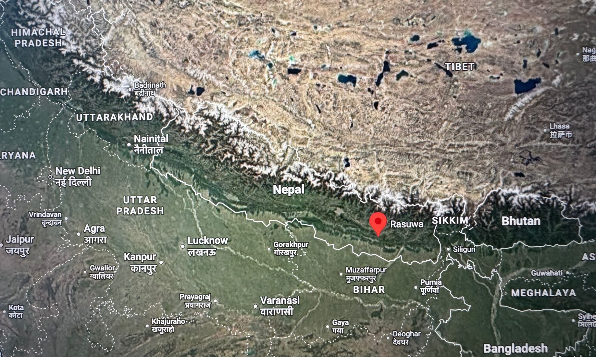
A catastrophic glacier-related collapse in the Himalayas has killed hundreds of people across Nepal and Tibet and left many more missing.
But beyond the shocking images and the rapidly evolving casualty figures lies a much bigger question for mountain regions around the world:
Could something similar happen in the Alps?
The answer is uncomfortable.
The precise sequence that produced the Nepal disaster is still being investigated. But glacier collapses, rock avalanches, sudden releases of glacial water, debris flows and naturally dammed lakes are not unique to the Himalayas. They are hazards that also exist in the Alps — and Alpine history provides some dramatic examples.
What can be very different is the ability to identify certain dangers in advance, monitor them and evacuate people before the mountain moves.
And even in the best-monitored Alpine countries, that warning cannot always be guaranteed.
What happened in Nepal?
On the morning of 26 August 2026, a massive collapse occurred in the Langtang National Park area close to Nepal’s border with Tibet.
According to the US Geological Survey, the catastrophic debris flow and flood was likely triggered by a glacial collapse, with the resulting flow travelling through downstream valleys and river systems.
UPDATE — New Analysis Points to a Major Glacier Collapse
Updated 4 September 2026: New satellite analysis and scientific assessments published after this article was originally written provide a clearer picture of the scale and sequence of the disaster in Nepal.
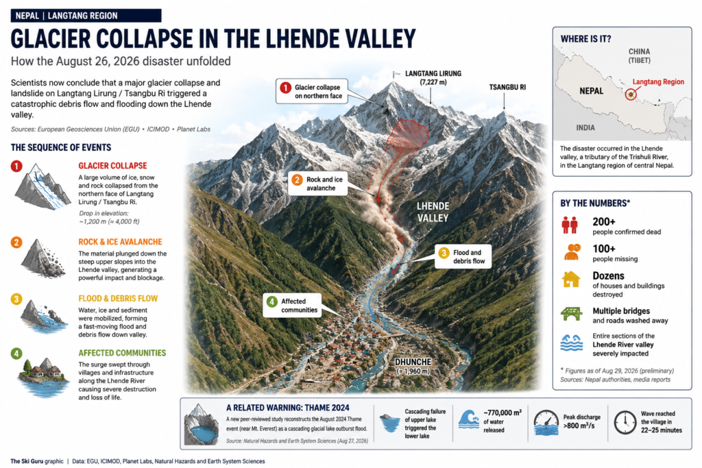
The evidence now points to a major rock and glacier collapse high above the Lhende Valley, where a large mass of ice and rock plunged roughly 1,200 metres (4,000 feet) down the mountainside. The collapse generated a powerful flow of debris, water and sediment that travelled downstream, producing the catastrophic flooding.
A new satellite-based assessment by Italy’s Fondazione Montagna Sicura has now provided an estimate of the scale of the initial failure. According to the foundation, approximately 0.32 square kilometres of glacier were involved, representing around 23.1 million cubic metres of ice. The analysis also identified a significant area of instability in the surrounding rock slope.
The assessment combined observations from several satellite platforms with glacier-thickness data produced by the University of Grenoble.
Initial reconstructions indicate that the failure of the rock slope and the involvement of the glacier generated a huge rock–ice avalanche. As the mass descended, it fragmented and incorporated additional water, sediment and debris — a process known as entrainment — allowing the event to grow and transform into a far more destructive cascade.
This distinction is important. The disaster was not simply a conventional glacial lake outburst flood. It demonstrates how a single high-mountain failure can evolve into a sequence of interconnected hazards extending far downstream from the original collapse.
Fondazione Montagna Sicura said this capacity for an initial event to transform and intensify along its path is precisely what makes such disasters particularly difficult to predict and manage. It also stressed that monitoring glaciers alone is no longer sufficient: scientists need to understand the complete high-mountain system, including ice, rock, permafrost, water and slope dynamics.
A newly published peer-reviewed study of the 2024 Thame glacial lake outburst flood provides another example of this cascading risk. Researchers reconstructed how the failure of an upper lake triggered a second lake below it, releasing approximately 770,000 m³ of water. The flood reached Thame within roughly 22–25 minutes.
For the Alps, the comparison should not be interpreted as suggesting that an identical Himalayan-scale event is imminent. However, the underlying issue is increasingly relevant: warming temperatures can destabilise glaciers, permafrost and high-mountain slopes, creating interconnected hazards that may extend well beyond the glacier itself.
Sources: European Geosciences Union (EGU); ICIMOD; Natural Hazards and Earth System Sciences; satellite analysis.
Satellite imagery examined by scientists indicates that part of the glacier and surrounding mountain material collapsed from high altitude, producing an extremely fast avalanche of ice, rock and debris.
Reuters reported that the lower section of a glacier appears to have broken away and fallen hundreds of metres into the valley below. Analysis of satellite imagery has also indicated failure of bedrock beneath or adjacent to the glacier, sending rock, ice and sediment into the drainage system.
That distinction matters.
Early descriptions of the disaster inevitably raised comparisons with a glacial lake outburst flood, or GLOF — the sudden release of water from a lake held back by ice, moraine or other natural material.
At present, however, the evidence points towards a more complex chain reaction.
The mountain and glacier collapsed.
Ice and rock accelerated down the slope.
The debris entered the river system.
Water, sediment and boulders were mobilised into an enormous downstream flood.
And the landscape itself was transformed.
A new lake then formed behind debris left by the disaster. By 28 August, Chinese authorities were reporting that this newly created barrier lake had begun overflowing, forcing rescue teams to withdraw from threatened areas.
So the lake now visible in the disaster zone appears to be a consequence of the original collapse rather than necessarily its initial cause.
That is an important distinction while scientists reconstruct exactly what happened.
Was anyone monitoring it?
This is perhaps the most troubling part of the story.
Nepal was not unaware of glacial risk.
The country has spent years studying glacial lakes, installing hydrological stations and developing early-warning systems.
Nepal’s Department of Hydrology and Meteorology operates automatic river-monitoring stations along the Trishuli system as part of a wider flood-warning network.
But monitoring a river is very different from predicting the precise moment when an enormous section of mountain and glacier will collapse several kilometres upstream.
Reports following the disaster indicated that the Trishuli River rose dramatically within around half an hour.
In a steep Himalayan valley, that can amount to almost no warning at all.
The International Centre for Integrated Mountain Development, ICIMOD, described the flood as having struck suddenly, with water levels rising rapidly.
The distinction is crucial.
A country can know that an area is vulnerable.
It can monitor rivers.
It can identify dangerous glacial lakes.
But that does not necessarily mean scientists can predict which particular slope will fail, on which day, and at what hour.
Nepal already knew its glaciers presented a growing risk
The broader danger has been known for years.
A major ICIMOD–UNDP inventory identified 47 potentially dangerous glacial lakes across the Koshi, Gandaki and Karnali river basins in Nepal, Tibet and India, including 21 within Nepal.
Nepal has also experienced at least 26 recorded glacial lake outburst floods since the 1970s.
The country is actively trying to reduce that risk.
In 2025, the Green Climate Fund approved a US$36.1 million programme, implemented with Nepal’s Department of Hydrology and Meteorology and UNDP, targeting particularly dangerous glacial lakes and improving early-warning systems.
There is therefore an important nuance.
This was not a country that had never heard of glacial hazards.
What appears to have happened is something harder to deal with: a rapidly cascading mountain failure whose precise location and timing may have been extremely difficult to forecast.
And that raises an obvious question for Europe.
Could this happen in the Alps?
Not necessarily on the same geographical scale or through precisely the same chain of events.
But the physical processes absolutely can.
Alpine glaciers are retreating rapidly, permafrost is degrading and previously frozen rock faces can become less stable.
Copernicus has documented the rapid loss of glacier ice across the European Alps, while scientists continue to investigate how changing glaciers and permafrost affect high-mountain hazards.
The Alps have already experienced glacier collapses, rock avalanches, debris flows, sudden releases of water and catastrophic failures of mountain slopes.
Some historical and recent examples show both the danger — and the extraordinary value of monitoring.
Blatten: when monitoring bought time
The destruction of Blatten in Switzerland in May 2025 provides perhaps the clearest recent Alpine comparison.
Instability developed high above the village around the Kleines Nesthorn and Birch Glacier.
Rock accumulated on the glacier, movement accelerated and authorities increasingly understood that a major collapse was possible.
Switzerland mobilised extensive monitoring and mapping resources. Swisstopo carried out repeated rapid-mapping flights at the request of the canton of Valais and the Federal Office for the Environment, documenting the changing mountain as the crisis evolved.
Authorities evacuated Blatten before the catastrophic collapse.
When millions of cubic metres of rock and ice eventually descended into the valley, much of the village was destroyed.
The mountain disaster could not be stopped.
But the population had largely been moved out of its path.
That is a fundamental lesson.
Monitoring cannot necessarily prevent a mountain from collapsing. Sometimes its greatest value is simply buying enough time to move people.
Planpincieux: watching a glacier 24 hours a day
The same principle is visible today in the Mont Blanc massif.
The Planpincieux Glacier above Val Ferret near Courmayeur has been monitored for years because of its instability.
During a period of renewed concern in July 2026, the Regione Autonoma Valle d’Aosta confirmed that monitoring was operating 24 hours a day, with regional technicians and Fondazione Montagna Sicura following glacier movement closely.
At the time, sections were moving at approximately 800 millimetres per day.
Radar interferometry, drones, cameras and continuous observations allow scientists to track acceleration and provide authorities with information that can be used for road closures, access restrictions or evacuations.
That does not make Planpincieux harmless.
It means authorities have an instrument panel with which to watch it.
Read more:
Planpincieux Glacier Retreat Highlights Growing Instability on Mont Blanc
Tête Rousse: the Alps have already suffered a deadly glacial flood
There is an even more direct historical warning on Mont Blanc.
On 12 July 1892, a huge pocket of water trapped within the Tête Rousse Glacier above Saint-Gervais suddenly emptied.
According to the Préfecture de Haute-Savoie, approximately 200,000 cubic metres of water and ice were released.
As the torrent moved downhill it incorporated sediment and debris, eventually producing a destructive flow estimated at around one million cubic metres.
175 people were killed.
More than a century later, scientists discovered another large accumulation of water within Tête Rousse.
Authorities drilled into the glacier and pumped water out in 2010 and 2011. The glacier has remained under surveillance, with monitoring and alert systems designed to reduce the risk to communities below.
The 1892 disaster is a reminder that catastrophic glacial floods are not something that happens only in the Himalayas.
They are part of Alpine history too.
Courmayeur has its own history of extreme avalanches
And glacial floods are not the only historical parallel.
Courmayeur itself has experienced extraordinary high-mountain avalanches.
In 1914, a major avalanche from the Brenva produced such a powerful powder blast that, according to historical records compiled by the Regione Autonoma Valle d’Aosta, it buried the Proment hut, brought down the bell tower of the small Notre-Dame de Guérison church and felled hundreds of mature trees.
The episode is particularly striking because Notre-Dame de Guérison sits at the entrance to Val Veny, an area today familiar to generations of visitors to Courmayeur.
It is also a reminder that the destructive footprint of a very large avalanche can extend beyond the main mass of snow itself. Large powder avalanches can produce powerful air blasts capable of damaging structures and forests beyond the dense avalanche deposit.
The Brenva sector has repeatedly demonstrated how dynamic the southern side of Mont Blanc can be.
Valle d’Aosta’s historical hazard records also document a catastrophic rockfall from the eastern side of Mont Blanc in 1920 and a major advance of the Brenva Glacier between 1923 and 1925, when a new lake formed at its front.
These events occurred long before today’s debate about climate change.
They matter because they show that large avalanches, glacier movements, rockfalls and sudden changes to Alpine landscapes are not new phenomena.
What is changing is the environmental background against which some of those hazards now develop — and the technology available to observe them.
Some dangers can be monitored. Others are much harder to see
This is where comparisons become more complicated.
Planpincieux gives scientists visible movement that can be measured.
A rock face may produce accelerating deformation.
A glacier may begin moving increasingly quickly.
A lake can be mapped and its level monitored.
But high mountains can also contain hidden water, internal glacier cavities and unstable interfaces between rock, ice and permafrost.
Different processes can then combine.
French authorities responsible for glacial hazards recognise several forms of danger, including sudden releases of water, serac falls, debris flows and situations in which displaced material blocks a valley, creates a lake and potentially produces another flood if that natural dam subsequently fails.
That description is particularly striking after the events in Nepal.
Sometimes the mountain provides measurable warning signs. Sometimes the warning may come only when the failure has already begun.
Randa, Mont Blanc and a changing Alpine risk landscape
The summer of 2026 has provided repeated reminders of how dynamic high-mountain conditions can become.
Authorities in Switzerland have been watching instability involving a hanging glacier above Randa near Zermatt.
Read more:
Weisshorn Hanging Glacier Above Randa Raises Concerns Near Zermatt
On Mont Blanc, extreme summer heat has coincided with glacier closures, rockfall and growing concern about conditions on high-alpine routes.
Read more:
15,000m³ Rockfall at Aiguille du Midi as Extreme Heat Destabilises Mont Blanc
Read more:
Alps Heatwave Brings Glacier Closures and Growing High-Mountain Risks
These incidents should not be presented as evidence that every Alpine mountain is about to collapse.
But neither should every event automatically be viewed in isolation.
The background environment in which these hazards develop is changing.
Did climate change cause the Nepal disaster?
It is too early to state that climate change directly caused this individual collapse.
That would go beyond the available evidence.
Scientists are still reconstructing the event.
What is much more firmly established is that warming is altering the conditions within which high-mountain hazards occur.
Glaciers are losing mass.
Permafrost is degrading.
Freeze-thaw patterns are changing.
Rock faces previously stabilised partly by ice can become less stable.
And new or expanding glacial lakes can develop as glaciers retreat.
Scientists examining the Nepal disaster have pointed to these longer-term changes across the Himalayas while stressing that the precise trigger and sequence of this particular collapse still require investigation.
The same broad processes are being studied in the Alps.
Read more:
Snow Conditions and a Warming Alpine Climate
The other difference is money
There is another part of this story that deserves far more attention.
Nepal is responsible for only a tiny fraction of global greenhouse-gas emissions, yet it is among the countries facing particularly severe risks from a changing climate.
And monitoring high mountains is expensive.
Switzerland can deploy radar, satellite imagery, aircraft and rapid-mapping teams above a threatened village.
France can drill through a glacier, pump water from it and maintain monitoring and alert systems for years.
Valle d’Aosta can operate 24-hour surveillance of Planpincieux.
Nepal faces high-mountain hazards across an enormous, remote and extraordinarily difficult landscape with far fewer financial and technical resources.
That is one of the uncomfortable realities of climate adaptation.
The physics of the mountain does not recognise economic borders. Our capacity to anticipate it does.
The lesson from Nepal is not that the Alps are next
It would be wrong — and alarmist — to say that the disaster in Nepal means an equivalent catastrophe is imminent in the Alps.
The geology, glacier systems, valley geometry, population, infrastructure and monitoring capacity are very different.
But it would be equally wrong to dismiss what happened as a remote Himalayan tragedy with no relevance elsewhere.
Blatten showed that even one of the richest and most heavily monitored mountain countries in the world cannot stop a mountain from collapsing.
Tête Rousse showed that the Alps can produce deadly glacial floods.
The historic Brenva avalanche demonstrated the extraordinary destructive potential of large Alpine avalanches close to communities such as Courmayeur.
Planpincieux shows how much technology and continuous observation may be required to manage just one unstable glacier.
And Nepal has demonstrated the other side of the equation:
when a high-mountain system fails suddenly, the time between detection and disaster may be measured not in days, but in minutes.
As glaciers retreat and high-mountain environments change, one of the defining questions for mountain communities may therefore be very simple:
How early can we see the danger coming?
And what happens when we cannot?
Sources
- European Geosciences Union (EGU) – Summary of the August 26th, 2026 Himalayan flash flood
https://blogs.egu.eu/divisions/hs/2026/08/28/summary-of-the-august-26th-2026-himalayan-flash-flood/ - Natural Hazards and Earth System Sciences (NHESS) – The 2024 cascading glacial lake outburst flood in the Thame Valley of Everest region, Nepal: process, impacts and implications
https://nhess.copernicus.org/articles/26/4131/2026/ - U.S. Geological Survey (USGS) – 2026 Nepal Debris Avalanche and Flash Flood
https://www.usgs.gov/programs/landslide-hazards/science/2026-nepal-debris-avalanche-and-flash-flood - International Centre for Integrated Mountain Development (ICIMOD) – Research and monitoring of glacial hazards in the Hindu Kush Himalaya
https://www.icimod.org/
U.S. Geological Survey (USGS)
2026 Nepal Debris Avalanche and Flash Flood
https://www.usgs.gov/programs/landslide-hazards/science/2026-nepal-debris-avalanche-and-flash-flood
Fondazione Montagna Sicura – Satellite-based volumetric assessment of the Langtang Lirung rock–ice avalanche, reported by AostaSera
https://aostasera.it/notizie/montagna/frana-in-nepal-fondazione-montagna-sicura-eventi-particolarmente-difficili-da-prevedere-e-gestire/
Reuters
Glacier collapse may have triggered deadly Nepal flash flood — 26 August 2026
https://www.reuters.com/business/environment/glacier-collapse-may-have-triggered-deadly-nepal-flash-flood-experts-say-2026-08-26/
Reuters
China responds to newly formed barrier lake near Nepal border — 28 August 2026
https://www.reuters.com/business/environment/china-rushes-minimise-risk-mountain-barrier-lake-near-border-with-nepal-2026-08-28/
Associated Press
Satellite analysis and Nepal flood reporting — August 2026
https://apnews.com/article/d8c11c2215ea0792e3612bf791e4299f
International Centre for Integrated Mountain Development (ICIMOD)
Major flash flood sweeps through Nepal’s Rasuwa district
https://www.icimod.org/press-release/major-flash-flood-sweeps-through-nepals-rasuwa-district-raising-fears-of-further-downstream-flooding/
Government of Nepal — Department of Hydrology and Meteorology
https://www.dhm.gov.np/
UNDP / ICIMOD
Potentially dangerous glacial lakes in the Koshi, Gandaki and Karnali river basins
https://www.undp.org/nepal/press-releases/report-icimod-and-undp-identifies-potentially-dangerous-glacial-lakes-koshi-gandaki-and-karnali-river-basins
UNDP Climate Promise
Building climate resilience in Nepal’s mountains and plains
https://climatepromise.undp.org/news-and-stories/building-climate-resilience-nepals-mountains-and-plains
Regione Autonoma Valle d’Aosta
Planpincieux Glacier — 24-hour monitoring
https://pressevda.regione.vda.it/it/news/ghiacciaio-di-planpincieux-la-situazione-e-stabile-prosegue-il-monitoraggio-h24
Regione Autonoma Valle d’Aosta
Historical catastrophic avalanches — Brenva/Courmayeur
https://www.regione.vda.it/allegato.aspx?pk=55607
Regione Autonoma Valle d’Aosta — Casa e Pericoli
Historical events in Courmayeur
https://casaepericoli.regione.vda.it/eventi-storici/courmayeur/
Préfecture de Haute-Savoie
Glacial hazards and the 1892 Tête Rousse disaster
https://www.haute-savoie.gouv.fr/index.php/layout/set/print/Actions-de-l-Etat/Prevenir-le-risque-et-se-proteger/Risques-naturels/Glaciaire/Definition
Préfecture de Haute-Savoie
Glacial-risk prevention and monitoring
https://www.haute-savoie.gouv.fr/Actions-de-l-Etat/Prevenir-le-risque-et-se-proteger/Risques-naturels/Glaciaire/Prevention-et-mesures
Swisstopo
Rapid Mapping following the Blatten crisis
https://www.swisstopo.admin.ch/fr/swisstopo-effectue-une-mission-de-rapid-mapping-a-blatten
Copernicus Climate Change Service
European glacier conditions
https://climate.copernicus.eu/esotc/2025/glaciers
World Bank
Nepal climate vulnerability and development
https://www.worldbank.org/en/news/press-release/2022/09/15/integrating-climate-change-into-nepal-s-development-strategy-key-to-build-resilience-says-new-world-bank-group-report
Read more:
Planpincieux Glacier Retreat Highlights Growing Instability on Mont Blanc
Weisshorn Hanging Glacier Above Randa Raises Concerns Near Zermatt
15,000m³ Rockfall at Aiguille du Midi as Extreme Heat Destabilises Mont Blanc
Alps Heatwave Brings Glacier Closures and Growing High-Mountain Risks
Snow Conditions and a Warming Alpine Climate
Check my Mountain Art on my Shop
You can go to my shop and see what have been inspiring me lately, lots mountain landscapes in soft pastels, and now in oils too. Go here to check my latest works!
Planning your next trip to the Italian Alps?
If you’re heading to the Aosta Valley, take a look at Il Cuore della Valdigne, our family-owned apartment in Morgex, available for rent when we’re not using it ourselves.
It’s an ideal base to:
- Ski in Courmayeur, La Thuile and Pila
- Enjoy the mountains in summer (hiking, biking, nature)
- Explore the Mont Blanc valley in a quieter, more authentic setting.
Check my Mountain Art on my Shop
You can go to my shop and see what have been inspiring me lately, lots mountain landscapes in soft pastels, and now in oils too. Go here to check my latest works!
Featured Image: Map of Rasuwa in Nepal, where the floodings occurred. Photo: Google Maps.


Discover more from The-Ski-Guru
Subscribe to get the latest posts sent to your email.
 Subscribe to The-Ski-Guru here.
You must be logged in to post a comment.